All posts by RojaTravels

Mudhumalai

TOURIST PLACES IN MUDHUMALAI

The Mudumalai sanctuary lies on the northern and north-western side of the Nilgiri (Blue Mountains), about 80 km north-west of Coimbatore in the extreme north-western corner of Tamil Nadu, on the interstate boundaries with Karnataka and Kerala states in southern India.
This 321-sq-kms wide sanctuary includes a National Park measuring an area of 103-sq-kms. The sanctuary has various mixtures of flat land, open grassland, swamp and valleys. Apart from the wide range of animal and bird life, the rich fauna of this sanctuary has made Mudumalai very popular with wildlife enthusiast.

Mudumalai Wildlife Sanctuary & National Parkmudhumalai_01

Mudumalai Wildlife Sanctuary & National Park is situated at the tri-junction of Tamil Nadu, Kerala and Karnataka on the North Eastern Slopes of the Nilgiris part of Western Ghats descending to the Mysore Plateau. An erstwhile game reserve, Mudumalai was declared a wildlife sanctuary with a 62 sq KM area in the early 1940 by the then Madras Presidency. With Bandipur Tiger Reserve (Karnataka) in the north, and Wynad Wildlife Sanctuary (Kerala) in the west the region forms a single, continuous viable habitat for a varied range of wildlife and is a part of the Nilgiri Biosphere Reserve.

Elephant Camp at Theppakkadu

The Theppakkadu Elephant Camp was established in 1972 in Mudumalai Range, which became the Mudumalai Wildlife Sanctuary in 1942. Its predecessor which served as Range Headquarters was established in 1910 near the Mudumalai game hut and later shifted to Theppakadu.

The Forest Department took up elephant capturing by the conventional Pit Method from 1889 onwards in the Madras Presidency, mainly to build up the work force of elephants needed for timber extraction. In the Anamallais where large areas were cleared for planting with teak, elephant capturing operation was taken up in 1889. Till 1972 more than 600 elephants were captured from wild to meet the demand for working elephants. In Mudumalai, elephant capturing was taken up in 1910 and continued till 1953. Thus there was a necessity of building up permanent Camp Sites with necessary infrastructure such as “Kraals” to train newly captured elephants. Surplus elephants and elephants considered not fit enough for timber extraction work such as calves were disposed off by conducting auction sales.

The use of local tribal people as elephant handlers clearly predated the establishment of elephant camps. This system was followed mainly because of the tribals’ expertise in the jungles, their long traditional association with capture and training elephants. Even today, the local tribals are the backbone of capturing, training and handling of elephant in the forest department. The Kurubas in Mudumalai, the Malasars, the Pullayars and Kadars of Anamallais are some of the tribals who have traditional knowledge in the art of capturing, training and handling elephants.
The captive elephants in the sanctuaries and national parks are no longer used for timber extraction work, since these areas are managed exclusively as protected areas. Hence the elephants are engaged mainly for the following purposes.

* Eco tourism
* Patrolling for anti poaching operations
* To control Man-Elephant conflict outside the Sanctuaries or other areas (Kumki work)
* As a conservation & Training center for Asian elephants which can be visited by public.

At present all the captive elephants are stationed either at Theppakkadu. This creates considerable pressure on the exciting fodder resources around these camps. The surrounding area appears depleted of fodder. The addition, indiscriminate lopping of fodder trees within 10 kms radius around the camps has resulted in the total absence of many of the fodder trees particularly many species of Ficus, Grewia, Kydia etc. For this purpose and also to avoid infections through fecal infestation, periodic shifting of camp to rest locations is Mandatory.
The camp has a permanent Stores shed to keep the grain rations as well as various equipments and accoutrements intended for the day today use in the camp.

The elephant camp has one Forester who is responsible for the day to day management of the camp. A forest guard and sometimes a Forest Watcher assist him. The forest Range officer has the administrative control over the supervision of the camp and the staff. Two persons, a mahout and cavady handle elephant over two meters in height. For the elephants under 2 meters in height such as the calves, only one attendant in the rank of Cavady is incharge. All the elephants, in addition to natural grazing, are provided with grain rations in cooked form. The standard practice and norms are being followed. The Forest Veterinary Officer is the authority to fix the quantum of grain rations for each animal according to its size, sex, capacity for work etc.

Elephants used for work such as timber dragging, patrolling or any other hard work are given “work rations” as and when they are used for work. Resting animals or animals that are not engaged for work are given the “Rest Diet” which is less than the work rations since these animals spend comparatively more time in grazing.
An elephant being a mega herbivore needs to spend at least 16-18 hours per day for grazing and the working elephants spend considerably less time. In addition they spend every for various types of works for which they are engaged. Hence they have to be compensated by providing more grain rations.
Some animals such as pregnant elephants, lactating or nursing mothers and animals, which are in run down condition, are prescribed special rations by the Forest Veterinary Officer or the Veterinary Assistant Surgeon in the camp. The grain rations normally consist of Horse gram and Ragi and sometimes Rice. The prescribed rations are given in cooked from both in the morning and evening at fixed hours. In Mudumalai large number tourists witness the evening feeding.

Standardised Wooden Moulds are used for making cakes of known size and weight to facilitate easy check. If the animals are being fed the proper quantity of rations are prescribed. Each feeding shed prominently displays the ration chart indicating the quantity of rations prescribed for each elephant. This chart also has the biodata of the animals. This practice had been in vogue for long time and is followed in every camp. The elephant camp at Theppakadu serves an important educational purpose, where over a lakh visitors every year, see the management and feeding of pachyderms and thereby increasing public awareness about the species. This also serves an important center for Research and Training for capture elephant management. Theppakadu elephant camp is located just nearer to Theppakadu Reception Centre. There are 23 elephants. Visitors are allowed to this camp in the evening during elephant feeding to witness the feeding process. Everyday 2 elephants perform pooja to Lord Vinayaka inside the camp. The elephants are used for joy riding of tourists early morning and evening on charges.

Other places of interest

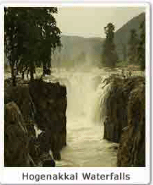
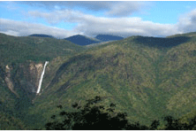
Theppakadu, is the Reception Point, where acomodation, Van rides and Elephant rides are arranged.
Ombetta vayal – swampy area is mid way between upper Kargudi and Mudumalai gamehut is a place to lookout for elephant and Bison.Mudumalai approached from Teppakkadu or Kargudi is a mixture of deciduous and grass area and rewarding with all the herbivores and carnivores. Benne is grass, bamboo and teak area with Sambar, Elephant, Gaur, Bear and Tiger. Scenic spots in the sanctuary includes the Moyar River-gorge and the Chief Minister’s Watchtower, view point at Kargudi and the Ombetta Lake. The van rides in Sand Road, Circular Road, Manradiar Road, Jayadev Avenue, Bombax Road, and Public roads . Kakkanalli – Torapalli road, Teppakkadu – Masanagudi road, Moyar – Masanagudi road are rewarding places to see most wild life in the Sanctuary

Ooty

TOURIST PLACES IN OOTY

Udhagamandalam (Ooty), the capital of Nilgiri district, is popularly known as the “Queen of hill stations’ among the tourist circuits. It is situated at a distance of 105 km away from Coimbatore. The height of the hills in the Nilgiri range varies between 2280 and 2290 metres, the highest peak being Doddabetta at a height of 2623 metres.

ooty_places

The Tea

The establishment of numerous tea estates made Ooty famous. Lofty mountains, dense forest, sprawling grasslands and miles and miles of tea gardens greet the passengers on most routes. The annual Tea and Tourism Festival attracts crowds in huge numbers. Visit Ooty during this festival, when tea lovers from all over the world converge. An occasion not to be missed!

Botanical Garden

This delightful water falls is 3km from the Yercaud lake. The surplus water from the Yercaud lake and the other reaches of the Shevaroy hills fall deep into the kiliyur valley. You can also trek to the bottom of the falls which is heavily wooded and takes about an hour from the lake.

Government Museum – Ooty

The Government Museum At Ooty The government museum, Mysore Road, Ooty has items of tribal objects, district’s ecological details and representative sculptural arts and crafts of Tamil Nadu. It was set up in 1989, with a view to provide education benefits to the residing and visiting population of Nilgiris district. Tourist Information Admission: Free Timings: 10.00 am to 1.00 pm and 2.00 pm to 5.00 pm Closed On: Fridays, Second Saturdays and National Holidays Ooty The nearest airport is at Coimbatore (100-km). Ooty on the narrow gauge railway is connected to Mettupalayam, which is directly connected to Coimbatore and Chennai on the broad gauge.

Hills and Views

Udhagamandalam (Ooty), the capital of Nilgiri district, is popularly known as the “Queen of hill stations” among the tourist circuits. It is situated at a distance of 105 kilometres from Coimbatore

Kalhatty Falls

The Kalhatty falls are located on the Kalhatty slopes at about 13-km from Udhagamandalam on the Udhagamandalam – Mysore Kalhatty ghat road.

Mini Garden and Rose Garden

The Rose Garden is situated about 3 to 4-km away from Charring Cross. Mini garden is also situated on the way to the boathouse where the children amusement park is housed.

Kandal Cross Shrine

Kandal cross, a Roman Catholic Shrine considered, as the Jerusalem of the East is located in Udhagamandalam in Tamil Nadu. The Nilgiri Catholics consider it as the “Calvary of Tamil Nadu”.

Hognekal

TOURIST PLACES IN HOGENAKKAL

Hogenakkal is situated at the borders of Karnataka, about 46 kms from Dharmapuri, the headquarters of the district of the same name. The river Kaveri which enters in Tamil Nadu as a big river flows here as natural falls, thus making the place serene and panoramic.

The word Hogenakkal is made of two words, Hoge and Kal. Hoge in Kannada means smoke and Kal means rocks. Hence, the Hogenakkal means smoky rocks. The river when falls on the rocks below, then the gushing force of the water looks like as if smoke is coming from the rocks so this place is as Hogenakkal.

Location

Hogenakkal is located on the Karnataka – Tamil Nadu border. It lies at the distance of 114 km from Salem and 133 km from Bangalore. Hogenakkal waterfalls are the part of river Kaveri and is about 250 meters above the sea level. It is one of the beautiful places in the state. When the water hits the rocks a fine cool spray rises, that is the reason these rocks have been given the name ‘Smoking Rock’.

Significance of its water

Taking a bath in the waterfalls of Hogenakkal is considered as extremely beneficial for the health. It is so because of the widely grown herbal plants in the nearby areas. The place is widely known for the curative power of its water.

Oil MassageHOGNEKAL_01

This is the place where you can take bath along with the rejuvenating oil massage. You may find lots of people there to do massage for the visitors. The massager’s or the maliswallas are expert in their work with the right knowledge of 14 massage points in the human body. Some of the major benefits of this oil massage includes – It increases circulation especially to the nerve endings, tone your muscles, increased mental alertness, smoothen the skin, improves elimination of impurities from the body and gives you better and deeper sleep at night.

Boating

A visit to the Hogenakkal waterfalls is incomplete without taking a ride in the waterproof basket boats covered in buffalo hide or plastic stretched over light-weight wicker frames. These boats are locally known as Teppa. These are among the oldest water crafts in the world. The boats man steer the boats through the rapids of rising water giving you the thrilling experience.

Yercaud

TOURIST PLACES IN YERCAUD

y1

Yercaud is a beautiful serene hill station nestled amidst the shevroy hills of south India. It is 4500ft above sea level with predominantly orange, pepper and coffee plantation estates.
Yercaud with a laid back attitude has a lake where much of low key action is boating.

Kiliyur Fallsy2

This delightful water falls is 3km from the Yercaud lake. The surplus water from the Yercaud lake and the other reaches of the Shevaroy hills fall deep into the kiliyur valley. You can also trek to the bottom of the falls which is heavily wooded and takes about an hour from the lake.

Lady’s seaty3

There is a natural rock formation in the form of a seat where reportedly a white English lady of yesteryears spent her evenings viewing the magnificent panaroma before one’s eyes. There is a man made viewing tower with telescopes through which one can see the Mettur Dam on clear days. One should not miss the night view of the salem town with millions of lurking lights.

Pagoda Pointy4

The name comes from the hill tribes having made four piles of random stones in a Pagoda or Pyramid formation reportedly to mark some event. There is a Rama Temple amidst the Pagodas.

Shevarayan Templey5

This temple dedicated to lord shevarayan is a narrow and dark cave and seated inside are God Shevarayan and Goddess Kaveri. The annual festival in the month of may is a colorful event in which thousands of tribal people of the hill take part.

Palani

TOURIST PLACES IN PALANI

Palani is a holiest resort for all the devotees of LORD MURUGAN. He is the son of LORD SIVA. Palani is located at the district of Madurai about 112km from Madurai and 152km from Trichi. The shrine of lord Arulmigu dandayudhapani swami is at the top of the hill nearly 500feet high, but there are several god and goddess surrounding the hill itself. Devotees reach the shrine either by climbing the fight of the steps or travel by the winches.Devotees believe that Lord Murugan came to this scared place. Narada Muni, a sage, brought a golden mango to the divine court of Lord Shiva and Parvathi and gave the miraculous fruit Jnanapalam to them but they announced whoever completes a round of globe first will get the fruit. Lord Murugan moves fastly with his peacock. Lord vinayakar symbolize his parents as a world, so he circumbulated around them and got the fruits. Murugan thought he was cheated. He decided to leave them so pravathi calls Murugan as “Pazham Nee”. Hence Palani gain its popularity.

Murugan Templepalani_01

* Murugan Temple – This is the prime attraction in Palani. One has top climb 670 steps to reach the temple. Alternatively ,there is a Haulage Winch [1] (a small rope train) and a Rope Car to goto the temple on the top of the hill. From the hill top, one can have a beautiful view of entire Palani town and the agricultural places around it.

Tiru Avinankudi Temple

* Tiru Avinankudi Temple is in the foot of the Palani Hills. This is oldest and largest temple. Usually before going to the main hill temple, devotees visit this temple.

Mariamman Kovil

* Mariamman Kovil is one of the famous temples in the surrounding area. This temple is located about 1 km from the bus stand.

Periyanayaki amman kovil

* Periyanayaki amman kovil or Aanai Kovil is one of the oldest temples in Palani. This temple is carved out of stones. There won’t be much crowd in this temple.

Kuthiraiyar Dam Falls

* Kuthiraiyar Dam Falls – located near Pappampatti, Palani. It has a water falls at the back of the dam. Once you reach the dam, one can find the way to go to falls with the help of the local villagers. There is a small trekking route available to reach the Kumbai which is about 1 km from the falls.

Thekkanthottam

* Thekkanthottam – another small water falls near the Palani. Water from this place is taken into Palani through pipes and stored in Palani Hill Water Tank named as Water dam, which then distributed to Palani after filtration. To reach this water falls, you have to take bus from Palani and get down at Thekkan thottam, where there is a forest department check post. From the village you have to walk 3 to 4 km to reach the falls. The places on the are beautiful and pleasant. On the way you can find a small dam. after that the path becomes difficult. Actually there is no pathway after this point. you have to climb small rocks and find your own way. you can find many small water falls of about 6 to 7 feet height. The mountain on the two sites of the path looks really good and dense. There is no way of getting lost in the forest, as you can always find your way back by following the water ways.

Varathamanathi Dam

* Varathamanathi Dam – A picnic spot where children can amuse themselves. It is on the way to Thekkanthottam and about 7 km from Palani. you can reach there by city buses and buses bound for Kodaikanal.

Kodai

TOURIST PLACES IN KODAIKANAL

Beside the waterfalls, cascades and green slopes there are more about Kodaikanal that promises to make your holiday a memorable one in kodaikanal. Kodaikanal is a mesmerizing hill station located amidst the Palani Hills of South India. It is one of the refreshing summer retreats in this part of the country. Set at an altitude of 2100 meters above sea level, Kodaikanal soothes the visitor with the cool climes.The surrounding forests provide great trekking opportunities and some awesome scenic views. There is also the beautiful Kodai Lake famous for its natural beauty. The not so adventurous can enjoy strolling around this place and spend a quite and relaxing vacation. A boat ride in this lake can also be a very good idea.

kodaikanal_01

The Lake

A magnificent star-shaped lake glitters like a jewel amidst the emerald green wooded slopes. This 24 hectare lake is skirted by 5 Kms long, black tapped road is focal point of kodai, This lake was created in 1863 by Sir Vere Hendry Levinge, who was the collector of Madurai, retired and settled in kodai.

Coaker’s Walk

A kilometre’s walk from the lake. It derives the name Lt. Coaker, who prepared the map of Kodai. Coaker’s Walk runs along a steep, emerald green wooded slope. From Coaker’s Walk one can have a breath-taking view of the plains below.

Bryant Park

This park is situated on the eastern side of the lake. It is noted for flowers, hybrids and grafts, Cut flowers are exported from here.A glass house which shelters fine varieties of flowers, Flower show is conducted every year in May as part of summer festival.

Green Valley View

It is about 5.5 Kms from the lake and located very close to Golf club, it commands a beautiful view of entire vaigai dam, As the valley is very deep, dense and dangerous, recommended to see with precautionary measures.

Shenbaganur Museum

This museum is MNaintained by the Sacred Heart College – Theological Seminary founded in 1895. It is devoted to archaeological remains and the flora and fauna of the hills. One of the best orchidoriums in the country with more that 300 species of orchids is also housed here. It is about 5.6 Kms from the lake. A Spanish Father Ugarthe, contributed his major collections to the Museum. Entrance fee Rs one per head. Working hours – 10 A.M to 11.30 A.M and 3P.M to 5P.

Dolmen Circle

Kodaikanal is put on anthropology map mainly because of the presence of pre-historic remains dating back to 5000 BC, thease are called Dolmens and Kistavens which are the dwelling and burial places of people of stone age and iron age. The Dolmens and fantastic stone of two very large erect stone slabs topped by a larger flat slab.

Thalaiyar Fallskodaikanal

This is also called as a Rat tail falls, The widest falls ranging from 13th Kilometer on the Ghat road to Kodai. It is one of the highest fall in India, with their 975 feet drop.